


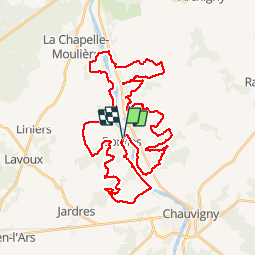
Zevtt - Bonnes 47 km

kipoura
User

Length
47 km

Max alt
137 m

Uphill gradient
659 m
Km-Effort
56 km

Min alt
54 m

Downhill gradient
663 m
Boucle
Yes
Creation date :
2019-05-03 17:10:22.223
Updated on :
2019-05-03 17:10:22.296
3h39
Difficulty : Difficult

FREE GPS app for hiking
 SityTrail
IGN / Geographical institutes
SityTrail Plus
The world is yours!
About
Trail Mountain bike of 47 km to be discovered at New Aquitaine, Vienne, Bonnes. This trail is proposed by kipoura.
Description
Une boucle VTT dans la vallée de la Vienne, au départ de Bonnes.Un circuit complet avec du roulant, du technique et de bonnes grimpettes ...à consommer sans modération. http://zevtt.free.fr
Positioning
Country:
France
Region :
New Aquitaine
Department/Province :
Vienne
Municipality :
Bonnes
Location:
Unknown
Start:(Dec)
Start:(UTM)
315979 ; 5164038 (31T) N.
Comments