


rives de l'Orne

Jeff_314
User
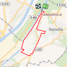

Length
6.1 km

Max alt
38 m

Uphill gradient
67 m
Km-Effort
7 km

Min alt
-2 m

Downhill gradient
66 m
Boucle
Yes
Creation date :
2014-12-10 00:00:00.0
Updated on :
2014-12-10 00:00:00.0
1h35
Difficulty : Medium

FREE GPS app for hiking
 SityTrail
IGN / Geographical institutes
SityTrail Plus
The world is yours!
About
Trail Walking of 6.1 km to be discovered at Normandy, Calvados, Ranville. This trail is proposed by Jeff_314.
Positioning
Country:
France
Region :
Normandy
Department/Province :
Calvados
Municipality :
Ranville
Location:
Unknown
Start:(Dec)
Start:(UTM)
698975 ; 5457695 (30U) N.
Comments
Quel gâchis! un parcours superbe dont la boucle est saboté e par une départementale pratiquement. infranchissable. Du reste les ronciers ont achevés le sabotage rendant le sentier impraticable et obligeant les randonneurs à faire demi-tour.