


20130412 Laviron

alexbnmr
User
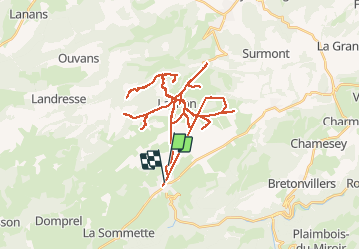

Length
63 km

Max alt
851 m

Uphill gradient
862 m
Km-Effort
74 km

Min alt
680 m

Downhill gradient
849 m
Boucle
No
Creation date :
2014-12-10 00:00:00.0
Updated on :
2014-12-10 00:00:00.0
5h39
Difficulty : Unknown

FREE GPS app for hiking
 SityTrail
IGN / Geographical institutes
SityTrail Plus
The world is yours!
About
Trail Other activity of 63 km to be discovered at Bourgogne-Franche-Comté, Doubs, Pierrefontaine-les-Varans. This trail is proposed by alexbnmr.
Description
Laviron
Positioning
Country:
France
Region :
Bourgogne-Franche-Comté
Department/Province :
Doubs
Municipality :
Pierrefontaine-les-Varans
Location:
Unknown
Start:(Dec)
Start:(UTM)
314124 ; 5233194 (32T) N.
Comments