


A1

ramsay
User
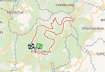

Length
17 km

Max alt
833 m

Uphill gradient
424 m
Km-Effort
23 km

Min alt
567 m

Downhill gradient
429 m
Boucle
Yes
Creation date :
2014-12-10 00:00:00.0
Updated on :
2014-12-10 00:00:00.0
1h28
Difficulty : Easy

FREE GPS app for hiking
 SityTrail
IGN / Geographical institutes
SityTrail Plus
The world is yours!
About
Trail Mountain bike of 17 km to be discovered at Auvergne-Rhône-Alpes, Loire, Panissières. This trail is proposed by ramsay.
Description
Randonnée montagne du matin - Départ Pannissières
Positioning
Country:
France
Region :
Auvergne-Rhône-Alpes
Department/Province :
Loire
Municipality :
Panissières
Location:
Unknown
Start:(Dec)
Start:(UTM)
604024 ; 5071794 (31T) N.
Comments