


corronsac

CANON2
User
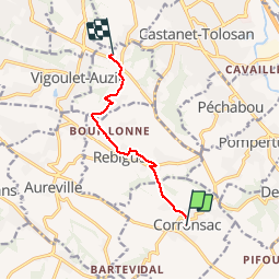

Length
7.5 km

Max alt
280 m

Uphill gradient
164 m
Km-Effort
9.6 km

Min alt
198 m

Downhill gradient
128 m
Boucle
No
Creation date :
2019-05-15 13:10:06.353
Updated on :
2019-05-15 13:10:06.475
1h43
Difficulty : Very easy

FREE GPS app for hiking
 SityTrail
IGN / Geographical institutes
SityTrail Plus
The world is yours!
About
Trail Walking of 7.5 km to be discovered at Occitania, Haute-Garonne, Corronsac. This trail is proposed by CANON2.
Positioning
Country:
France
Region :
Occitania
Department/Province :
Haute-Garonne
Municipality :
Corronsac
Location:
Unknown
Start:(Dec)
Start:(UTM)
378259 ; 4814482 (31T) N.
Comments