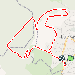
Côteaux de Ludres

MMarie
User

Length
6.3 km

Max alt
423 m

Uphill gradient
156 m
Km-Effort
8.3 km

Min alt
286 m

Downhill gradient
156 m
Boucle
Yes
Creation date :
2014-12-10 00:00:00.0
Updated on :
2014-12-10 00:00:00.0
1h35
Difficulty : Easy

FREE GPS app for hiking
 SityTrail
IGN / Geographical institutes
SityTrail Plus
The world is yours!
About
Trail Walking of 6.3 km to be discovered at Grand Est, Meurthe-et-Moselle, Ludres. This trail is proposed by MMarie.
Positioning
Country:
France
Region :
Grand Est
Department/Province :
Meurthe-et-Moselle
Municipality :
Ludres
Location:
Unknown
Start:(Dec)
Start:(UTM)
290715 ; 5388683 (32U) N.
Comments