Trail Other activity Bedretto - Entre Tessin et Valais - Etape 1/4 - Photo

Entre Tessin et Valais - Etape 1/4

 Romrando
Romrando

User

© OpenStreetMap contributors
Length
Length
6.5 km
Max alt
Max alt
2579 m
Uphill gradient
Uphill gradient
1251 m
Km-Effort
Km-Effort  
19 km
Min alt
Min alt
1314 m
Downhill gradient
Downhill gradient
2 m
Boucle
Boucle
No
Creation date :
2014-12-11 00:00:00.0
Updated on :
2014-12-11 00:00:00.0

(0 Reviews)

Other activity
Other activity
--
Difficulty : Unknown

Scan this QR Code to open this trail in the SityTrail application

FREE GPS app for hiking

Logo SityTrail SityTrail

IGN / Geographical institutes

Download SityTrail from the App Store Download SityTrail from Google Play

Logo SityTrail SityTrail World

The world is yours!

Download SityTrail from the App Store Download SityTrail from Google Play Download SityTrail on Huawei AppGallery

About

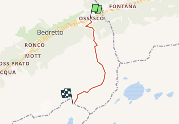
Trail Other activity of 6.5 km to be discovered at Ticino, Distretto di Leventina, Bedretto. This trail is proposed by Romrando.

Description

Source:geocities.com/romrando - 29.7.05

Superbe randonnée de 4 jours qui vous amènera d''Airolo au pied du Val Bedretto dans le château hydro-électrique tessinois (nombreux lacs de barrage et malheureusement quelques lignes électriques peu esthétiques) en passant au pied du "Cristallina", contournant par le nord le "Basodino" , traversant la sauvage région du Nufenen avant de plonger sur l''Italie et de contourner par le sud le massif de l''Ofenhorn puis de rejoindre la Suisse par la vallée cristalline du "Binntal".  

Itinéraire : D''Airolo à Ossasco par le car postal.

Puis par le sentier balisé par le Val Torta gagner la cabane Cristallina.

Variante : de la cabane Cristallina poursuive en descente vers le lac Sfundau et par le col supérieur que l''on franchit avant de descendre vers le SE au-dessus de gradins puis par la suite directement vers le lac Bianco. Ensuite par la route jusqu''à Robiei et son hôtel d''altitude.

Elevation profile

Positioning

Country:
Switzerland
Region :
Ticino
Department/Province :
Distretto di Leventina
Municipality :
Bedretto
Location:
Unknown
Start:(UTM)
464553 ; 5151064 (32T) N.

Trails nearby

Trail On foot Bedretto - Alla Baita-Alpe di Cruina - Photo
On foot
PRO

On foot

Easy
Bedretto, Ticino, Distretto di Leventina, Switzerland
4.8 km | 8.7 km-effort
1h 58min
No
Trail On foot Airolo - Ospizio San Gottardo-Hospental - Photo
On foot
PRO

On foot

Easy
Airolo, Ticino, Distretto di Leventina, Switzerland
9.1 km | 11.6 km-effort
2h 38min
No
Trail On foot Bedretto - Alpe di Cristallina-Passo Cristallina - Photo
On foot
PRO

On foot

Easy
Bedretto, Ticino, Distretto di Leventina, Switzerland
4.9 km | 7.4 km-effort
1h 41min
No
Trail On foot Airolo - Motto Bartola-Ospizio San Gottardo - Photo
On foot
PRO

On foot

Easy
Airolo, Ticino, Distretto di Leventina, Switzerland
4.6 km | 6.6 km-effort
1h 29min
No
Trail Other activity Airolo - y10_val_canaria - Photo
Other activity
GUIDE+

Other activity

Very easy
Airolo, Ticino, Distretto di Leventina, Switzerland
16.2 km | 28 km-effort
6h 27min
No
Trail Other activity Airolo - y10_lago_tremorgio - Photo
Other activity
GUIDE+

Other activity

Very easy
Airolo, Ticino, Distretto di Leventina, Switzerland
16.4 km | 34 km-effort
7h 29min
No
Trail Walking Airolo - Aussichtsreiche Tour ins Bedrettotal - Photo
Walking
GUIDE+

Walking

Very easy
Airolo, Ticino, Distretto di Leventina, Switzerland
13.9 km | 20 km-effort
Unknown
No
Trail Other activity Airolo - Lago Tremorgio - Photo
Other activity
alternatives-wandern

Other activity

Very easy
Airolo, Ticino, Distretto di Leventina, Switzerland
15.5 km | 36 km-effort
Unknown
No
Trail Other activity Airolo - Winterhorn - Seenwanderung - Photo
Other activity
claudeag

Other activity

Very easy
Airolo, Ticino, Distretto di Leventina, Switzerland
11.5 km | 19.1 km-effort
Unknown
Yes


Close
My subscriptions