


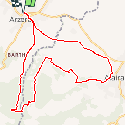
ARZENS

CANON2
User

Length
11.7 km

Max alt
328 m

Uphill gradient
257 m
Km-Effort
15.1 km

Min alt
186 m

Downhill gradient
257 m
Boucle
Yes
Creation date :
2019-05-15 13:10:05.074
Updated on :
2019-05-15 13:10:05.169
3h14
Difficulty : Easy

FREE GPS app for hiking
 SityTrail
IGN / Geographical institutes
SityTrail Plus
The world is yours!
About
Trail Walking of 11.7 km to be discovered at Occitania, Aude, Arzens. This trail is proposed by CANON2.
Positioning
Country:
France
Region :
Occitania
Department/Province :
Aude
Municipality :
Arzens
Location:
Unknown
Start:(Dec)
Start:(UTM)
435746 ; 4783362 (31T) N.
Comments