


CUBSERVIES

CANON2
User
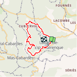

Length
13.8 km

Max alt
801 m

Uphill gradient
571 m
Km-Effort
21 km

Min alt
321 m

Downhill gradient
568 m
Boucle
Yes
Creation date :
2019-05-15 13:10:03.912
Updated on :
2019-05-15 13:10:03.971
--
Difficulty : Medium

FREE GPS app for hiking
 SityTrail
IGN / Geographical institutes
SityTrail Plus
The world is yours!
About
Trail Walking of 13.8 km to be discovered at Occitania, Aude, Roquefère. This trail is proposed by CANON2.
Positioning
Country:
France
Region :
Occitania
Department/Province :
Aude
Municipality :
Roquefère
Location:
Unknown
Start:(Dec)
Start:(UTM)
450873 ; 4803210 (31T) N.
Comments