


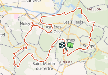
AUTOUR DE L''ABBAYE DE ROYAUMONT PAR LA FORET DE CARNELLE

NUITEVEN
User

Length
29 km

Max alt
218 m

Uphill gradient
571 m
Km-Effort
37 km

Min alt
21 m

Downhill gradient
569 m
Boucle
Yes
Creation date :
2014-12-10 00:00:00.0
Updated on :
2014-12-10 00:00:00.0
7h50
Difficulty : Easy

FREE GPS app for hiking
 SityTrail
IGN / Geographical institutes
SityTrail Plus
The world is yours!
About
Trail Walking of 29 km to be discovered at Ile-de-France, Val-d'Oise, Viarmes. This trail is proposed by NUITEVEN.
Positioning
Country:
France
Region :
Ile-de-France
Department/Province :
Val-d'Oise
Municipality :
Viarmes
Location:
Unknown
Start:(Dec)
Start:(UTM)
453871 ; 5440653 (31U) N.
Comments