


FORET D'HALATTE

NUITEVEN
User

Length
17.9 km

Max alt
158 m

Uphill gradient
336 m
Km-Effort
22 km

Min alt
28 m

Downhill gradient
337 m
Boucle
Yes
Creation date :
2014-12-10 00:00:00.0
Updated on :
2014-12-10 00:00:00.0
4h48
Difficulty : Easy

FREE GPS app for hiking
 SityTrail
IGN / Geographical institutes
SityTrail Plus
The world is yours!
About
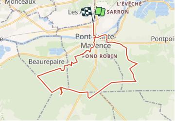
Trail Walking of 17.9 km to be discovered at Hauts-de-France, Oise, Pont-Sainte-Maxence. This trail is proposed by NUITEVEN.
Positioning
Country:
France
Region :
Hauts-de-France
Department/Province :
Oise
Municipality :
Pont-Sainte-Maxence
Location:
Unknown
Start:(Dec)
Start:(UTM)
471148 ; 5461963 (31U) N.
Comments