


Vigneulles

MMarie
User
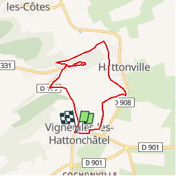

Length
6.2 km

Max alt
357 m

Uphill gradient
133 m
Km-Effort
8 km

Min alt
242 m

Downhill gradient
133 m
Boucle
Yes
Creation date :
2014-12-10 00:00:00.0
Updated on :
2014-12-10 00:00:00.0
1h43
Difficulty : Easy

FREE GPS app for hiking
 SityTrail
IGN / Geographical institutes
SityTrail Plus
The world is yours!
About
Trail Walking of 6.2 km to be discovered at Grand Est, Meuse, Vigneulles-lès-Hattonchâtel. This trail is proposed by MMarie.
Positioning
Country:
France
Region :
Grand Est
Department/Province :
Meuse
Municipality :
Vigneulles-lès-Hattonchâtel
Location:
Vigneulles-lès-Hattonchâtel
Start:(Dec)
Start:(UTM)
697797 ; 5428866 (31U) N.
Comments