FORET DE MONTCEAUX ET BORDS DE MARNE

NUITEVEN
User
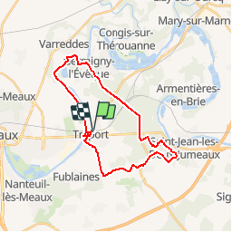

Length
25 km

Max alt
163 m

Uphill gradient
259 m
Km-Effort
28 km

Min alt
44 m

Downhill gradient
260 m
Boucle
Yes
Creation date :
2017-09-20 00:00:00.0
Updated on :
2017-09-20 00:00:00.0
6h11
Difficulty : Easy

FREE GPS app for hiking
 SityTrail
IGN / Geographical institutes
SityTrail Plus
The world is yours!
About
Trail Walking of 25 km to be discovered at Ile-de-France, Seine-et-Marne, Trilport. This trail is proposed by NUITEVEN.
Positioning
Country:
France
Region :
Ile-de-France
Department/Province :
Seine-et-Marne
Municipality :
Trilport
Location:
Unknown
Start:(Dec)
Start:(UTM)
496313 ; 5423048 (31U) N.
Comments