


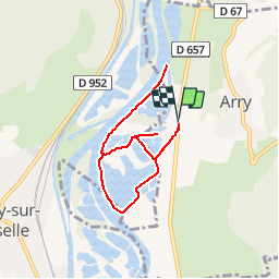
Arry - La Lobe

edmondnagel
User

Length
6.6 km

Max alt
183 m

Uphill gradient
44 m
Km-Effort
7.2 km

Min alt
167 m

Downhill gradient
43 m
Boucle
Yes
Creation date :
2014-12-10 00:00:00.0
Updated on :
2014-12-10 00:00:00.0
1h36
Difficulty : Easy

FREE GPS app for hiking
 SityTrail
IGN / Geographical institutes
SityTrail Plus
The world is yours!
About
Trail Walking of 6.6 km to be discovered at Grand Est, Moselle, Arry. This trail is proposed by edmondnagel.
Description
Les étangs - La Moselle
Positioning
Country:
France
Region :
Grand Est
Department/Province :
Moselle
Municipality :
Arry
Location:
Unknown
Start:(Dec)
Start:(UTM)
284083 ; 5430979 (32U) N.
Comments