


Monts de Blonds Hte Vienne

ramsay
User
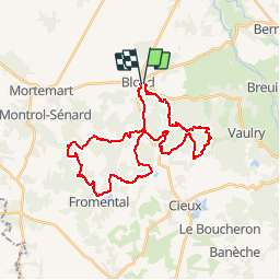

Length
34 km

Max alt
498 m

Uphill gradient
869 m
Km-Effort
46 km

Min alt
294 m

Downhill gradient
873 m
Boucle
Yes
Creation date :
2014-12-10 00:00:00.0
Updated on :
2014-12-10 00:00:00.0
2h55
Difficulty : Medium

FREE GPS app for hiking
 SityTrail
IGN / Geographical institutes
SityTrail Plus
The world is yours!
About
Trail Mountain bike of 34 km to be discovered at New Aquitaine, Haute-Vienne, Blond. This trail is proposed by ramsay.
Description
Autour de Blond
Positioning
Country:
France
Region :
New Aquitaine
Department/Province :
Haute-Vienne
Municipality :
Blond
Location:
Unknown
Start:(Dec)
Start:(UTM)
346876 ; 5100879 (31T) N.
Comments