


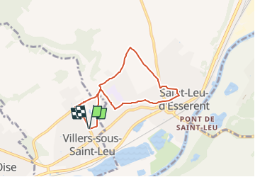
Le tir à l'arc de St-Leu - 5,9 km

Pousscailleux
User

Length
5.9 km

Max alt
77 m

Uphill gradient
72 m
Km-Effort
6.8 km

Min alt
32 m

Downhill gradient
70 m
Boucle
Yes
Creation date :
2014-12-10 00:00:00.0
Updated on :
2022-11-28 13:43:48.976
1h12
Difficulty : Easy

FREE GPS app for hiking
 SityTrail
IGN / Geographical institutes
SityTrail Plus
The world is yours!
About
Trail Walking of 5.9 km to be discovered at Hauts-de-France, Oise, Villers-sous-Saint-Leu. This trail is proposed by Pousscailleux.
Description
Départ : Parking du Foyer Rural de Villers-sous-Saint-Leu.
Par le fosse aux Lièvres et le GR11, puis la sente Francois Villon
Positioning
Country:
France
Region :
Hauts-de-France
Department/Province :
Oise
Municipality :
Villers-sous-Saint-Leu
Location:
Unknown
Start:(Dec)
Start:(UTM)
456200 ; 5451277 (31U) N.
Comments