


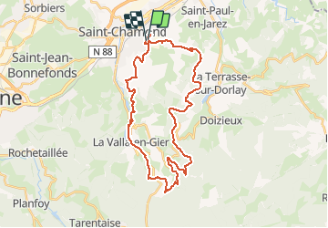
ST CHAMOND 35 KM

ramsay
User

Length
34 km

Max alt
1004 m

Uphill gradient
1205 m
Km-Effort
51 km

Min alt
384 m

Downhill gradient
1205 m
Boucle
Yes
Creation date :
2014-12-10 00:00:00.0
Updated on :
2014-12-10 00:00:00.0
3h25
Difficulty : Difficult

FREE GPS app for hiking
 SityTrail
IGN / Geographical institutes
SityTrail Plus
The world is yours!
About
Trail Mountain bike of 34 km to be discovered at Auvergne-Rhône-Alpes, Loire, Saint-Chamond. This trail is proposed by ramsay.
Description
Randonnée St Cham VTT 2013
Positioning
Country:
France
Region :
Auvergne-Rhône-Alpes
Department/Province :
Loire
Municipality :
Saint-Chamond
Location:
Unknown
Start:(Dec)
Start:(UTM)
619516 ; 5036373 (31T) N.
Comments