


Laifour bis

rvapeldo
User GUIDE
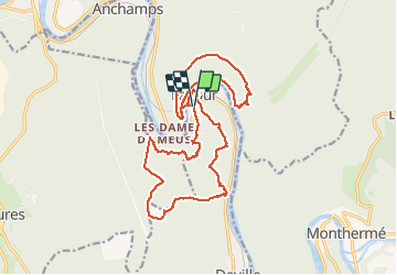

Length
20 km

Max alt
406 m

Uphill gradient
852 m
Km-Effort
32 km

Min alt
121 m

Downhill gradient
854 m
Boucle
Yes
Creation date :
2018-10-06 08:33:34.382
Updated on :
2018-10-06 08:33:34.56
6h32
Difficulty : Difficult

FREE GPS app for hiking
 SityTrail
IGN / Geographical institutes
SityTrail Plus
The world is yours!
About
Trail Walking of 20 km to be discovered at Grand Est, Ardennes, Laifour. This trail is proposed by rvapeldo.
Positioning
Country:
France
Region :
Grand Est
Department/Province :
Ardennes
Municipality :
Laifour
Location:
Unknown
Start:(Dec)
Start:(UTM)
621460 ; 5530004 (31U) N.
Comments