


La G�nilacoise 2013

ramsay
User

Length
46 km

Max alt
874 m

Uphill gradient
1063 m
Km-Effort
60 km

Min alt
296 m

Downhill gradient
1063 m
Boucle
Yes
Creation date :
2014-12-10 00:00:00.0
Updated on :
2014-12-10 00:00:00.0
3h50
Difficulty : Difficult

FREE GPS app for hiking
 SityTrail
IGN / Geographical institutes
SityTrail Plus
The world is yours!
About
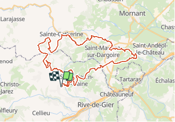
Trail Mountain bike of 46 km to be discovered at Auvergne-Rhône-Alpes, Loire, Genilac. This trail is proposed by ramsay.
Description
Randonn�e du club VTT de G�nilac parcours 45 Km 2013


Positioning
Country:
France
Region :
Auvergne-Rhône-Alpes
Department/Province :
Loire
Municipality :
Genilac
Location:
Unknown
Start:(Dec)
Start:(UTM)
622578 ; 5044817 (31T) N.
Comments