


Randonnée de la Fourme 2011

ramsay
User
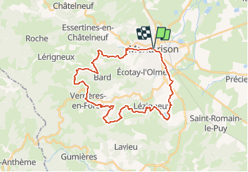

Length
33 km

Max alt
857 m

Uphill gradient
837 m
Km-Effort
44 km

Min alt
388 m

Downhill gradient
836 m
Boucle
Yes
Creation date :
2014-12-10 00:00:00.0
Updated on :
2014-12-10 00:00:00.0
2h49
Difficulty : Difficult

FREE GPS app for hiking
 SityTrail
IGN / Geographical institutes
SityTrail Plus
The world is yours!
About
Trail Mountain bike of 33 km to be discovered at Auvergne-Rhône-Alpes, Loire, Montbrison. This trail is proposed by ramsay.
Description
Randonnée de Montbrison 2011 parcours 32 Km
Positioning
Country:
France
Region :
Auvergne-Rhône-Alpes
Department/Province :
Loire
Municipality :
Montbrison
Location:
Unknown
Start:(Dec)
Start:(UTM)
582857 ; 5050947 (31T) N.
Comments