


zaterdag

Frings
User
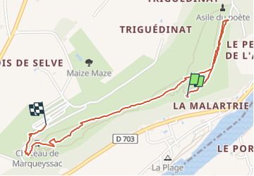

Length
2.1 km

Max alt
203 m

Uphill gradient
64 m
Km-Effort
3 km

Min alt
137 m

Downhill gradient
78 m
Boucle
No
Creation date :
2014-12-10 00:00:00.0
Updated on :
2014-12-10 00:00:00.0
1h01
Difficulty : Unknown

FREE GPS app for hiking
 SityTrail
IGN / Geographical institutes
SityTrail Plus
The world is yours!
About
Trail Other activity of 2.1 km to be discovered at New Aquitaine, Dordogne, Vézac. This trail is proposed by Frings.
Positioning
Country:
France
Region :
New Aquitaine
Department/Province :
Dordogne
Municipality :
Vézac
Location:
Unknown
Start:(Dec)
Start:(UTM)
355488 ; 4965234 (31T) N.
Comments