


THIVERNY_12,6 km_Trace GPS

Pousscailleux
User
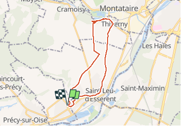

Length
12.6 km

Max alt
88 m

Uphill gradient
153 m
Km-Effort
14.7 km

Min alt
28 m

Downhill gradient
152 m
Boucle
Yes
Creation date :
2014-12-10 00:00:00.0
Updated on :
2014-12-10 00:00:00.0
2h56
Difficulty : Medium

FREE GPS app for hiking
 SityTrail
IGN / Geographical institutes
SityTrail Plus
The world is yours!
About
Trail Walking of 12.6 km to be discovered at Hauts-de-France, Oise, Villers-sous-Saint-Leu. This trail is proposed by Pousscailleux.
Photos


Positioning
Country:
France
Region :
Hauts-de-France
Department/Province :
Oise
Municipality :
Villers-sous-Saint-Leu
Location:
Unknown
Start:(Dec)
Start:(UTM)
456220 ; 5451277 (31U) N.
Comments