


20130506 Monnetay

alexbnmr
User
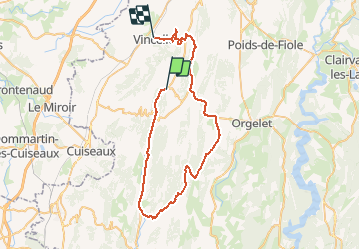

Length
52 km

Max alt
590 m

Uphill gradient
626 m
Km-Effort
62 km

Min alt
221 m

Downhill gradient
895 m
Boucle
No
Creation date :
2014-12-10 00:00:00.0
Updated on :
2014-12-10 00:00:00.0
1h54
Difficulty : Medium

FREE GPS app for hiking
 SityTrail
IGN / Geographical institutes
SityTrail Plus
The world is yours!
About
Trail Cycle of 52 km to be discovered at Bourgogne-Franche-Comté, Jura, Augisey. This trail is proposed by alexbnmr.
Positioning
Country:
France
Region :
Bourgogne-Franche-Comté
Department/Province :
Jura
Municipality :
Augisey
Location:
Unknown
Start:(Dec)
Start:(UTM)
691098 ; 5158418 (31T) N.
Comments