


villeperdrix col de chaude bonne

losjo
User
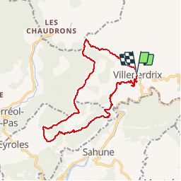

Length
17.7 km

Max alt
928 m

Uphill gradient
774 m
Km-Effort
28 km

Min alt
425 m

Downhill gradient
773 m
Boucle
Yes
Creation date :
2014-12-10 00:00:00.0
Updated on :
2014-12-10 00:00:00.0
--
Difficulty : Medium

FREE GPS app for hiking
 SityTrail
IGN / Geographical institutes
SityTrail Plus
The world is yours!
About
Trail Walking of 17.7 km to be discovered at Auvergne-Rhône-Alpes, Drôme, Villeperdrix. This trail is proposed by losjo.
Positioning
Country:
France
Region :
Auvergne-Rhône-Alpes
Department/Province :
Drôme
Municipality :
Villeperdrix
Location:
Unknown
Start:(Dec)
Start:(UTM)
681958 ; 4923463 (31T) N.
Comments
très belle randonnée A refaire