


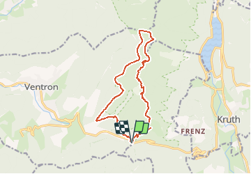
Du Col d'Oderen au Grand Ventron - Ventron

tracegps
User

Length
13.7 km

Max alt
1203 m

Uphill gradient
580 m
Km-Effort
21 km

Min alt
891 m

Downhill gradient
581 m
Boucle
Yes
Creation date :
2014-12-10 00:00:00.0
Updated on :
2014-12-10 00:00:00.0
4h00
Difficulty : Difficult

FREE GPS app for hiking
 SityTrail
IGN / Geographical institutes
SityTrail Plus
The world is yours!
About
Trail Snowshoes of 13.7 km to be discovered at Grand Est, Vosges, Ventron. This trail is proposed by tracegps.
Description
Rando effectuée en raquette, avec une halte pour manger à la ferme auberge. Départ du col d'Oderen.
Photos


Positioning
Country:
France
Region :
Grand Est
Department/Province :
Vosges
Municipality :
Ventron
Location:
Unknown
Start:(Dec)
Start:(UTM)
344375 ; 5309823 (32T) N.
Comments