


GRR2-7B

JLDECK
User
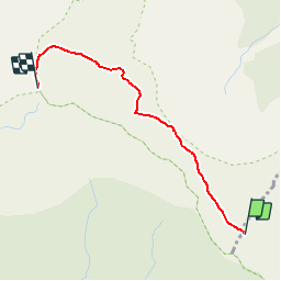

Length
2.9 km

Max alt
3042 m

Uphill gradient
574 m
Km-Effort
8.7 km

Min alt
2479 m

Downhill gradient
14 m
Boucle
No
Creation date :
2019-02-16 18:54:23.804
Updated on :
2019-02-16 18:54:23.816
1h57
Difficulty : Unknown

FREE GPS app for hiking
 SityTrail
IGN / Geographical institutes
SityTrail Plus
The world is yours!
About
Trail Walking of 2.9 km to be discovered at Réunion, Unknown, Saint-Benoît. This trail is proposed by JLDECK.
Description
Refuge caverne Dufour - Piton des Neiges
Positioning
Country:
France
Region :
Réunion
Department/Province :
Unknown
Municipality :
Saint-Benoît
Location:
Unknown
Start:(Dec)
Start:(UTM)
343804 ; 7664956 (40K) S.
Comments