


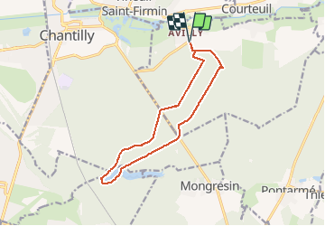
Avily_Etangs de la Reine Blanche_trace GPS simplifiée_12,1 km

Pousscailleux
User

Length
12.2 km

Max alt
74 m

Uphill gradient
101 m
Km-Effort
13.5 km

Min alt
46 m

Downhill gradient
101 m
Boucle
Yes
Creation date :
2015-03-26 00:00:00.0
Updated on :
2015-03-26 00:00:00.0
3h04
Difficulty : Medium

FREE GPS app for hiking
 SityTrail
IGN / Geographical institutes
SityTrail Plus
The world is yours!
About
Trail Walking of 12.2 km to be discovered at Hauts-de-France, Oise, Avilly-Saint-Léonard. This trail is proposed by Pousscailleux.
Description
Départ du Parking de la rue du Calvaire à Avily-Saint-Léonard.
Positioning
Country:
France
Region :
Hauts-de-France
Department/Province :
Oise
Municipality :
Avilly-Saint-Léonard
Location:
Unknown
Start:(Dec)
Start:(UTM)
464500 ; 5448738 (31U) N.
Comments