


Nature dans les Monts du Forez

ramsay
User
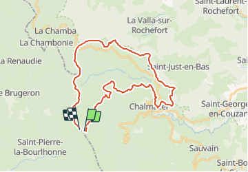

Length
34 km

Max alt
1422 m

Uphill gradient
1037 m
Km-Effort
48 km

Min alt
882 m

Downhill gradient
1032 m
Boucle
No
Creation date :
2014-12-10 00:00:00.0
Updated on :
2014-12-10 00:00:00.0
3h02
Difficulty : Difficult

FREE GPS app for hiking
 SityTrail
IGN / Geographical institutes
SityTrail Plus
The world is yours!
About
Trail Mountain bike of 34 km to be discovered at Auvergne-Rhône-Alpes, Loire, Chalmazel-Jeansagnière. This trail is proposed by ramsay.
Description
Boucle depuis le Col du Béal en passant par Chalmazel
Positioning
Country:
France
Region :
Auvergne-Rhône-Alpes
Department/Province :
Loire
Municipality :
Chalmazel-Jeansagnière
Location:
Chalmazel
Start:(Dec)
Start:(UTM)
561305 ; 5059394 (31T) N.
Comments
Chemins avec beaucoup de pierres, impossible à rouler. Chemins non tracés dans la bruyère. Dommage, le paysage est superbe