


La Culminante

ramsay
User

Length
41 km

Max alt
864 m

Uphill gradient
1109 m
Km-Effort
55 km

Min alt
467 m

Downhill gradient
1103 m
Boucle
Yes
Creation date :
2017-11-08 00:00:00.0
Updated on :
2017-11-08 00:00:00.0
3h31
Difficulty : Difficult

FREE GPS app for hiking
 SityTrail
IGN / Geographical institutes
SityTrail Plus
The world is yours!
About
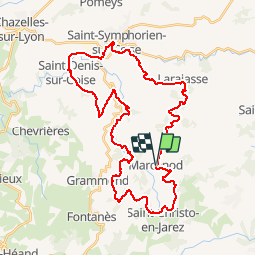
Trail Mountain bike of 41 km to be discovered at Auvergne-Rhône-Alpes, Loire, Marcenod. This trail is proposed by ramsay.
Description
Départ depuis Marcenod parcours 40 km
Positioning
Country:
France
Region :
Auvergne-Rhône-Alpes
Department/Province :
Loire
Municipality :
Marcenod
Location:
Unknown
Start:(Dec)
Start:(UTM)
615648 ; 5047542 (31T) N.
Comments