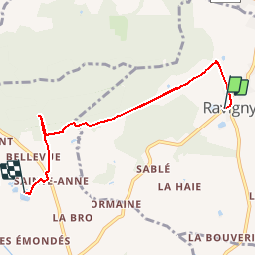
Trail Walking Ravigny - BALADE RAVIGNY GC - Photo
© OpenStreetMap contributors
Length
Length
5.9 km
Max alt
Max alt
347 m
Uphill gradient
Uphill gradient
202 m
Km-Effort
Km-Effort  
8.4 km
Min alt
Min alt
198 m
Downhill gradient
Downhill gradient
165 m
Boucle
Boucle
No
Creation date :
2014-12-10 00:00:00.0
Updated on :
2014-12-10 00:00:00.0

(0 Reviews)

Walking
Walking
1h48
Difficulty : Easy

Scan this QR Code to open this trail in the SityTrail application

FREE GPS app for hiking

Logo SityTrail SityTrail

IGN / Geographical institutes

Download SityTrail from the App Store Download SityTrail from Google Play

Logo SityTrail SityTrail Plus

The world is yours!

Download SityTrail from the App Store Download SityTrail from Google Play Download SityTrail on Huawei AppGallery

About

Trail Walking of 5.9 km to be discovered at Pays de la Loire, Mayenne, Ravigny. This trail is proposed by yannick-p.

Description

GEOCACHING - CHEMIN DES QUATRE SAISONS ET DES CINQ SENS : Petite série de 8 caches sur le chemin des écoliers entre Ravigny et Champfrémont. Départ du bourg près de l'école direction la chapelle Ste Anne et le verger conservatoire.

Elevation profile

Points of interest

Point of interest Champfrémont - 5 - CHEMIN DES QUATRE SAISONS ET DES CINQ SENS - Photo
yannick-p
Point of interest Champfrémont - 6 - CHEMIN DES QUATRE SAISONS ET DES CINQ SENS - Photo
yannick-p
Point of interest Champfrémont - 7 - CHEMIN DES QUATRE SAISONS ET DES CINQ SENS - Photo
yannick-p
Point of interest Champfrémont - 8 - CHEMIN DES QUATRE SAISONS ET DES CINQ SENS - Photo
yannick-p

Positioning

Country:
France
Region :
Pays de la Loire
Department/Province :
Mayenne
Municipality :
Ravigny
Location:
Unknown
Start:(UTM)
717029 ; 5369946 (30U) N.


Close
My subscriptions