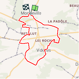
Boucle mondeville par videlles

Glurps
User

Length
16.1 km

Max alt
148 m

Uphill gradient
191 m
Km-Effort
18.6 km

Min alt
85 m

Downhill gradient
197 m
Boucle
Yes
Creation date :
2014-12-10 00:00:00.0
Updated on :
2014-12-10 00:00:00.0
4h02
Difficulty : Very easy

FREE GPS app for hiking
 SityTrail
IGN / Geographical institutes
SityTrail Plus
The world is yours!
About
Trail Walking of 16.1 km to be discovered at Ile-de-France, Essonne, Mondeville. This trail is proposed by Glurps.
Positioning
Country:
France
Region :
Ile-de-France
Department/Province :
Essonne
Municipality :
Mondeville
Location:
Unknown
Start:(Dec)
Start:(UTM)
456857 ; 5370949 (31U) N.
Comments