


Randonnée 2013 Essertines en Chatelneuf

ramsay
User
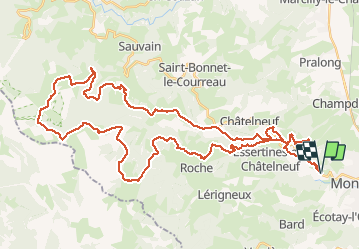

Length
55 km

Max alt
1383 m

Uphill gradient
1498 m
Km-Effort
75 km

Min alt
550 m

Downhill gradient
1499 m
Boucle
Yes
Creation date :
2014-12-10 00:00:00.0
Updated on :
2014-12-10 00:00:00.0
5h15
Difficulty : Difficult

FREE GPS app for hiking
 SityTrail
IGN / Geographical institutes
SityTrail Plus
The world is yours!
About
Trail Mountain bike of 55 km to be discovered at Auvergne-Rhône-Alpes, Loire, Essertines-en-Châtelneuf. This trail is proposed by ramsay.
Description
Les Hautes Chaumes depuis Esertines en Chatelneuf. Parcours 2013 de 55 Km.
Positioning
Country:
France
Region :
Auvergne-Rhône-Alpes
Department/Province :
Loire
Municipality :
Essertines-en-Châtelneuf
Location:
Unknown
Start:(Dec)
Start:(UTM)
580388 ; 5051464 (31T) N.
Comments