


123456

randodan
User
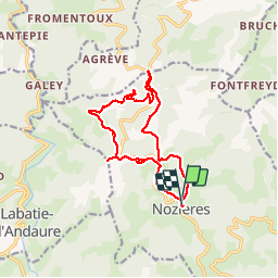

Length
14.3 km

Max alt
1032 m

Uphill gradient
493 m
Km-Effort
21 km

Min alt
744 m

Downhill gradient
513 m
Boucle
Yes
Creation date :
2014-12-10 00:00:00.0
Updated on :
2014-12-10 00:00:00.0
4h09
Difficulty : Unknown

FREE GPS app for hiking
 SityTrail
IGN / Geographical institutes
SityTrail Plus
The world is yours!
About
Trail Walking of 14.3 km to be discovered at Auvergne-Rhône-Alpes, Ardèche, Nozières. This trail is proposed by randodan.
Photos

Positioning
Country:
France
Region :
Auvergne-Rhône-Alpes
Department/Province :
Ardèche
Municipality :
Nozières
Location:
Unknown
Start:(Dec)
Start:(UTM)
621548 ; 4987456 (31T) N.
Comments