


Thomas

Frings
User

Length
37 km

Max alt
338 m

Uphill gradient
609 m
Km-Effort
45 km

Min alt
204 m

Downhill gradient
613 m
Boucle
Yes
Creation date :
2014-12-10 00:00:00.0
Updated on :
2014-12-10 00:00:00.0
1h51
Difficulty : Unknown

FREE GPS app for hiking
 SityTrail
IGN / Geographical institutes
SityTrail Plus
The world is yours!
About
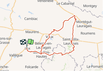
Trail Cycle of 37 km to be discovered at Occitania, Haute-Garonne, Lux. This trail is proposed by Frings.
Positioning
Country:
France
Region :
Occitania
Department/Province :
Haute-Garonne
Municipality :
Lux
Location:
Unknown
Start:(Dec)
Start:(UTM)
401381 ; 4810051 (31T) N.
Comments