FORT DUGOMMIER

CANON2
User
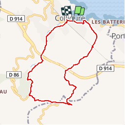

Length
8.5 km

Max alt
302 m

Uphill gradient
346 m
Km-Effort
13.1 km

Min alt
5 m

Downhill gradient
347 m
Boucle
Yes
Creation date :
2019-05-15 13:09:57.972
Updated on :
2019-05-15 13:09:58.049
2h49
Difficulty : Easy

FREE GPS app for hiking
 SityTrail
IGN / Geographical institutes
SityTrail Plus
The world is yours!
About
Trail Walking of 8.5 km to be discovered at Occitania, Pyrénées-Orientales, Collioure. This trail is proposed by CANON2.
Positioning
Country:
France
Region :
Occitania
Department/Province :
Pyrénées-Orientales
Municipality :
Collioure
Location:
Unknown
Start:(Dec)
Start:(UTM)
506924 ; 4707979 (31T) N.
Comments