


Cosprons-Madaloc

CANON2
User
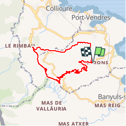

Length
15.8 km

Max alt
637 m

Uphill gradient
634 m
Km-Effort
24 km

Min alt
37 m

Downhill gradient
633 m
Boucle
Yes
Creation date :
2019-05-15 13:09:57.475
Updated on :
2019-05-15 13:09:57.57
5h20
Difficulty : Difficult

FREE GPS app for hiking
 SityTrail
IGN / Geographical institutes
SityTrail Plus
The world is yours!
About
Trail Walking of 15.8 km to be discovered at Occitania, Pyrénées-Orientales, Port-Vendres. This trail is proposed by CANON2.
Positioning
Country:
France
Region :
Occitania
Department/Province :
Pyrénées-Orientales
Municipality :
Port-Vendres
Location:
Unknown
Start:(Dec)
Start:(UTM)
508791 ; 4704955 (31T) N.
Comments