


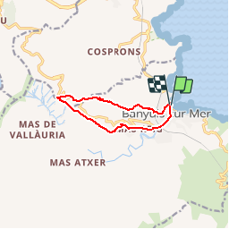
Banyuls-Col des Gascons

CANON2
User

Length
9.4 km

Max alt
380 m

Uphill gradient
390 m
Km-Effort
14.6 km

Min alt
3 m

Downhill gradient
390 m
Boucle
Yes
Creation date :
2019-05-15 13:09:56.994
Updated on :
2019-05-15 13:09:57.057
3h04
Difficulty : Medium

FREE GPS app for hiking
 SityTrail
IGN / Geographical institutes
SityTrail Plus
The world is yours!
About
Trail Walking of 9.4 km to be discovered at Occitania, Pyrénées-Orientales, Banyuls-sur-Mer. This trail is proposed by CANON2.
Positioning
Country:
France
Region :
Occitania
Department/Province :
Pyrénées-Orientales
Municipality :
Banyuls-sur-Mer
Location:
Unknown
Start:(Dec)
Start:(UTM)
510645 ; 4703261 (31T) N.
Comments