


les hauts de Port-Vendres

CANON2
User
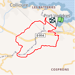

Length
8.5 km

Max alt
257 m

Uphill gradient
261 m
Km-Effort
12 km

Min alt
11 m

Downhill gradient
258 m
Boucle
Yes
Creation date :
2019-05-15 13:09:56.503
Updated on :
2019-05-15 13:09:56.566
2h30
Difficulty : Easy

FREE GPS app for hiking
 SityTrail
IGN / Geographical institutes
SityTrail Plus
The world is yours!
About
Trail Walking of 8.5 km to be discovered at Occitania, Pyrénées-Orientales, Port-Vendres. This trail is proposed by CANON2.
Positioning
Country:
France
Region :
Occitania
Department/Province :
Pyrénées-Orientales
Municipality :
Port-Vendres
Location:
Unknown
Start:(Dec)
Start:(UTM)
508658 ; 4707054 (31T) N.
Comments