


Cerbère

CANON2
User
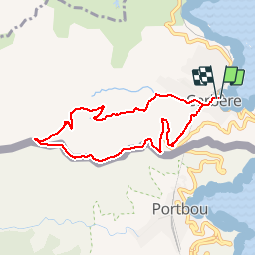

Length
8 km

Max alt
352 m

Uphill gradient
348 m
Km-Effort
12.6 km

Min alt
8 m

Downhill gradient
347 m
Boucle
Yes
Creation date :
2019-05-15 13:09:55.995
Updated on :
2019-05-15 13:09:56.058
2h30
Difficulty : Easy

FREE GPS app for hiking
 SityTrail
IGN / Geographical institutes
SityTrail Plus
The world is yours!
About
Trail Walking of 8 km to be discovered at Occitania, Pyrénées-Orientales, Cerbère. This trail is proposed by CANON2.
Description
Passage sous terain sous la gare de Cerbère
Positioning
Country:
France
Region :
Occitania
Department/Province :
Pyrénées-Orientales
Municipality :
Cerbère
Location:
Unknown
Start:(Dec)
Start:(UTM)
513627 ; 4698807 (31T) N.
Comments
Super