


Savoillan à Brantes

jean52
User
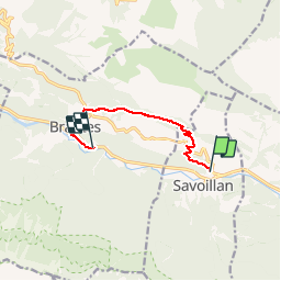

Length
7.8 km

Max alt
826 m

Uphill gradient
343 m
Km-Effort
12.5 km

Min alt
467 m

Downhill gradient
385 m
Boucle
No
Creation date :
2014-12-10 00:00:00.0
Updated on :
2014-12-10 00:00:00.0
2h42
Difficulty : Easy

FREE GPS app for hiking
 SityTrail
IGN / Geographical institutes
SityTrail Plus
The world is yours!
About
Trail Walking of 7.8 km to be discovered at Provence-Alpes-Côte d'Azur, Vaucluse, Savoillan. This trail is proposed by jean52.
Positioning
Country:
France
Region :
Provence-Alpes-Côte d'Azur
Department/Province :
Vaucluse
Municipality :
Savoillan
Location:
Unknown
Start:(Dec)
Start:(UTM)
689917 ; 4894919 (31T) N.
Comments