


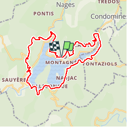
Tour du laouzas

CANON2
User

Length
20 km

Max alt
941 m

Uphill gradient
555 m
Km-Effort
27 km

Min alt
744 m

Downhill gradient
552 m
Boucle
Yes
Creation date :
2019-05-15 13:09:54.296
Updated on :
2019-05-15 13:09:54.361
5h51
Difficulty : Easy

FREE GPS app for hiking
 SityTrail
IGN / Geographical institutes
SityTrail Plus
The world is yours!
About
Trail Walking of 20 km to be discovered at Occitania, Tarn, Nages. This trail is proposed by CANON2.
Description
Suivre le nouveau balisage (GR 653) de Villelongue a Vergnerols longeant le bord du lac, bien plus agréable
Positioning
Country:
France
Region :
Occitania
Department/Province :
Tarn
Municipality :
Nages
Location:
Unknown
Start:(Dec)
Start:(UTM)
482046 ; 4832904 (31T) N.
Comments