


Rocherath

flip96
User

Length
24 km

Max alt
691 m

Uphill gradient
396 m
Km-Effort
29 km

Min alt
523 m

Downhill gradient
393 m
Boucle
Yes
Creation date :
2014-12-10 00:00:00.0
Updated on :
2014-12-10 00:00:00.0
6h00
Difficulty : Medium

FREE GPS app for hiking
 SityTrail
IGN / Geographical institutes
SityTrail Plus
The world is yours!
About
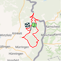
Trail Walking of 24 km to be discovered at Wallonia, Liège, Büllingen. This trail is proposed by flip96.
Description
Rondwandeling vanuit Rocherath (Krinkelt) 24km.
Langs de Lichtenbach, Olef, Jansbach, Edesbach en Holzwarche.
Zeer mooie wandeling!
Opmerkingen? flip96@home.nl
Positioning
Country:
Belgium
Region :
Wallonia
Department/Province :
Liège
Municipality :
Büllingen
Location:
Rocherath
Start:(Dec)
Start:(UTM)
310746 ; 5590631 (32U) N.
Comments