


Villeneuve a.c. 2012

Tollard
User
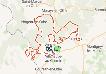

Length
57 km

Max alt
307 m

Uphill gradient
1197 m
Km-Effort
73 km

Min alt
162 m

Downhill gradient
1192 m
Boucle
Yes
Creation date :
2014-12-10 00:00:00.0
Updated on :
2014-12-10 00:00:00.0
4h37
Difficulty : Medium

FREE GPS app for hiking
 SityTrail
IGN / Geographical institutes
SityTrail Plus
The world is yours!
About
Trail Mountain bike of 57 km to be discovered at Grand Est, Aube, Villeneuve-au-Chemin. This trail is proposed by Tollard.
Positioning
Country:
France
Region :
Grand Est
Department/Province :
Aube
Municipality :
Villeneuve-au-Chemin
Location:
Unknown
Start:(Dec)
Start:(UTM)
563308 ; 5327068 (31U) N.
Comments