
tour de Madeloc

phi14
User
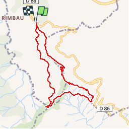

Length
9.5 km

Max alt
637 m

Uphill gradient
414 m
Km-Effort
15.1 km

Min alt
327 m

Downhill gradient
415 m
Boucle
Yes
Creation date :
2014-12-10 00:00:00.0
Updated on :
2014-12-10 00:00:00.0
3h21
Difficulty : Medium

FREE GPS app for hiking
 SityTrail
IGN / Geographical institutes
SityTrail Plus
The world is yours!
About
Trail Walking of 9.5 km to be discovered at Occitania, Pyrénées-Orientales, Collioure. This trail is proposed by phi14.
Photos

Positioning
Country:
France
Region :
Occitania
Department/Province :
Pyrénées-Orientales
Municipality :
Collioure
Location:
Unknown
Start:(Dec)
Start:(UTM)
505352 ; 4705826 (31T) N.
Comments