


cazal St. antonin cazal

fmindo
User
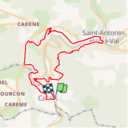

Length
21 km

Max alt
338 m

Uphill gradient
591 m
Km-Effort
28 km

Min alt
115 m

Downhill gradient
594 m
Boucle
Yes
Creation date :
2014-12-10 00:00:00.0
Updated on :
2014-12-10 00:00:00.0
3h04
Difficulty : Unknown

FREE GPS app for hiking
 SityTrail
IGN / Geographical institutes
SityTrail Plus
The world is yours!
About
Trail Mountain bike of 21 km to be discovered at Occitania, Tarn-et-Garonne, Saint-Antonin-Noble-Val. This trail is proposed by fmindo.
Positioning
Country:
France
Region :
Occitania
Department/Province :
Tarn-et-Garonne
Municipality :
Saint-Antonin-Noble-Val
Location:
Unknown
Start:(Dec)
Start:(UTM)
397751 ; 4886200 (31T) N.
Comments
cirq