


Courselles sur Yvette

c.chehere
User
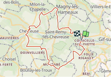

Length
20 km

Max alt
177 m

Uphill gradient
463 m
Km-Effort
26 km

Min alt
69 m

Downhill gradient
468 m
Boucle
Yes
Creation date :
2017-12-16 07:46:45.178
Updated on :
2024-11-01 05:14:58.565
5h57
Difficulty : Difficult

FREE GPS app for hiking
 SityTrail
IGN / Geographical institutes
SityTrail Plus
The world is yours!
About
Trail Walking of 20 km to be discovered at Ile-de-France, Essonne, Gif-sur-Yvette. This trail is proposed by c.chehere.
Description
Boucle autour de St Rémy les chevreuses au départ de la gare RER de Courselles sur Yvette
Positioning
Country:
France
Region :
Ile-de-France
Department/Province :
Essonne
Municipality :
Gif-sur-Yvette
Location:
Unknown
Start:(Dec)
Start:(UTM)
433720 ; 5394584 (31U) N.
Comments