


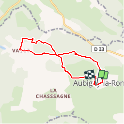
W - 2018 - 18 Aubigny la Ronce (rando douce)

clabidault
User

Length
6.7 km

Max alt
492 m

Uphill gradient
175 m
Km-Effort
9 km

Min alt
380 m

Downhill gradient
178 m
Boucle
Yes
Creation date :
2018-05-01 09:46:36.959
Updated on :
2018-12-31 14:57:57.966
--
Difficulty : Very easy

FREE GPS app for hiking
 SityTrail
IGN / Geographical institutes
SityTrail Plus
The world is yours!
About
Trail On foot of 6.7 km to be discovered at Bourgogne-Franche-Comté, Côte-d'Or, Aubigny-la-Ronce. This trail is proposed by clabidault.
Positioning
Country:
France
Region :
Bourgogne-Franche-Comté
Department/Province :
Côte-d'Or
Municipality :
Aubigny-la-Ronce
Location:
Unknown
Start:(Dec)
Start:(UTM)
622207 ; 5204877 (31T) N.
Comments