Trail Walking Blangy-le-Château - 20180606-blangy - Photo
 doudet
doudet

User

© OpenStreetMap contributors
Length
Length
19.1 km
Max alt
Max alt
157 m
Uphill gradient
Uphill gradient
277 m
Km-Effort
Km-Effort  
23 km
Min alt
Min alt
52 m
Downhill gradient
Downhill gradient
277 m
Boucle
Boucle
Yes
Creation date :
2018-06-13 13:14:10.391
Updated on :
2018-06-13 17:08:13.049

(0 Reviews)

Walking
Walking
4h58
Difficulty : Medium

Scan this QR Code to open this trail in the SityTrail application

FREE GPS app for hiking

Logo SityTrail SityTrail

IGN / Geographical institutes

Download SityTrail from the App Store Download SityTrail from Google Play

Logo SityTrail SityTrail World

The world is yours!

Download SityTrail from the App Store Download SityTrail from Google Play Download SityTrail on Huawei AppGallery

About

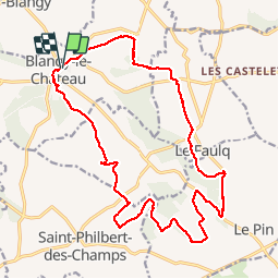
Trail Walking of 19.1 km to be discovered at Normandy, Calvados, Blangy-le-Château. This trail is proposed by doudet.

Description

Boucle A-R au Départ de Blangy le Château

Elevation profile

Positioning

Country:
France
Region :
Normandy
Department/Province :
Calvados
Municipality :
Blangy-le-Château
Location:
Unknown
Start:(UTM)
301755 ; 5458296 (31U) N.

Trails nearby

Trail Walking Saint-Philbert-des-Champs - St Philbert des champs  - Photo
Walking
Eve - Line

Walking

Easy
(1)
Saint-Philbert-des-Champs, Normandy, Calvados, France
12.5 km | 14.4 km-effort
2h 22min
Yes
Trail Walking Bonneville-la-Louvet - Autour de Bonneville la Louvet - Photo
Walking
tracegps

Walking

Difficult
Bonneville-la-Louvet, Normandy, Calvados, France
17.6 km | 21 km-effort
4h 10min
Yes
Trail Walking Saint-Philbert-des-Champs - St Philbert des Champs  - Photo
Walking
Eve - Line

Walking

Medium
Saint-Philbert-des-Champs, Normandy, Calvados, France
16.3 km | 18.6 km-effort
3h 12min
Yes
Trail Nordic walking Fierville-les-Parcs - quai maurel - Photo
Nordic walking
ablatge

Nordic walking

Medium
Fierville-les-Parcs, Normandy, Calvados, France
12.7 km | 15.3 km-effort
3h 34min
Yes
Trail Nordic walking Fierville-les-Parcs - quai maurel - Photo
Nordic walking
ablatge

Nordic walking

Medium
Fierville-les-Parcs, Normandy, Calvados, France
12.7 km | 15.3 km-effort
3h 34min
Yes
Trail Mountain bike Le Faulq - Randonnée en Pays d'Auge - Le Pin - Photo
Mountain bike
tracegps

Mountain bike

Medium
Le Faulq, Normandy, Calvados, France
138 km | 165 km-effort
2h 0min
No
Trail Mountain bike Le Pin - Randonnée VTT Saint Julien sur Calonne - Photo
Mountain bike
tracegps

Mountain bike

Medium
Le Pin, Normandy, Calvados, France
41 km | 47 km-effort
2h 15min
Yes
Trail Mountain bike Saint-Philbert-des-Champs - Rando de Saint Philbert des Champs 2010 - Photo
Mountain bike
tracegps

Mountain bike

Difficult
Saint-Philbert-des-Champs, Normandy, Calvados, France
34 km | 41 km-effort
2h 30min
Yes
Trail Mountain bike Saint-Philbert-des-Champs - Randonnée St Philbert des Champs du 31/01/2010 27 Km - Photo
Mountain bike
tracegps

Mountain bike

Difficult
Saint-Philbert-des-Champs, Normandy, Calvados, France
22 km | 27 km-effort
2h 15min
Yes


Close
My subscriptions