Trail Motorbike Lépin-le-Lac - GTA 2018 - ETAPE 10 - Photo
© OpenStreetMap contributors
Length
Length
246 km
Max alt
Max alt
1353 m
Uphill gradient
Uphill gradient
5919 m
Km-Effort
Km-Effort  
324 km
Min alt
Min alt
230 m
Downhill gradient
Downhill gradient
5678 m
Boucle
Boucle
No
Creation date :
2018-07-24 10:00:56.018
Updated on :
2018-07-24 10:18:05.631

(0 Reviews)

Motorbike
Motorbike
10h45
Difficulty : Very easy

Scan this QR Code to open this trail in the SityTrail application

FREE GPS app for hiking

Logo SityTrail SityTrail

IGN / Geographical institutes

Download SityTrail from the App Store Download SityTrail from Google Play

Logo SityTrail SityTrail World

The world is yours!

Download SityTrail from the App Store Download SityTrail from Google Play Download SityTrail on Huawei AppGallery

About

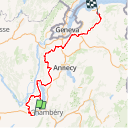
Trail Motorbike of 246 km to be discovered at Auvergne-Rhône-Alpes, Savoy, Lépin-le-Lac. This trail is proposed by lagardienne.

Description

Grande traversée des Alpes et Petites Routes du Soleil effectuées en moto.
Plus de détail sur http://lejardindelolo.fr/
3079 km en 12 jours, avec une Varadéro 125.

Elevation profile

Photos

Positioning

Country:
France
Region :
Auvergne-Rhône-Alpes
Department/Province :
Savoy
Municipality :
Lépin-le-Lac
Location:
Unknown
Start:(UTM)
717004 ; 5046810 (31T) N.

Trails nearby

Trail Walking Aiguebelette-le-Lac - Mont grêle  - Photo
Walking
grattounette

Walking

Difficult
(2)
Aiguebelette-le-Lac, Auvergne-Rhône-Alpes, Savoy, France
17.8 km | 32 km-effort
8h 5min
Yes
Trail Walking La Motte-Servolex - 73 Croix du signal via Château Renard  - Photo
Walking
jeanlucm88

Walking

Medium
La Motte-Servolex, Auvergne-Rhône-Alpes, Savoy, France
12.3 km | 19.9 km-effort
4h 2min
Yes
Trail Walking Aiguebelette-le-Lac - 73 aiguebelette zel - Photo
Walking
GUIDE
randodyssée

Walking

Medium
Aiguebelette-le-Lac, Auvergne-Rhône-Alpes, Savoy, France
14.2 km | 27 km-effort
5h 22min
No
Trail Walking Aiguebelette-le-Lac - Montagne de l'Epine 2.6.24 - Photo
Walking
GUIDE
fredetpascale

Walking

Medium
Aiguebelette-le-Lac, Auvergne-Rhône-Alpes, Savoy, France
6.9 km | 12 km-effort
2h 45min
Yes
Trail Walking Aiguebelette-le-Lac - Mont Grêle  - Photo
Walking
Zasa

Walking

Medium
Aiguebelette-le-Lac, Auvergne-Rhône-Alpes, Savoy, France
16.3 km | 30 km-effort
5h 0min
Yes
Trail Walking Aiguebelette-le-Lac - Belvédère du Rocher du Corbeau - Photo
Walking
GuyVachet

Walking

Difficult
(1)
Aiguebelette-le-Lac, Auvergne-Rhône-Alpes, Savoy, France
5 km | 9.3 km-effort
2h 7min
Yes
Trail Walking Aiguebelette-le-Lac - aiguebelette, col du crucifix - Photo
Walking
francislassauce

Walking

Difficult
Aiguebelette-le-Lac, Auvergne-Rhône-Alpes, Savoy, France
9.8 km | 17.4 km-effort
4h 14min
Yes
Trail Walking Saint-Thibaud-de-Couz - Mont Grèle - Photo
Walking
Michel_Martin

Walking

Medium
Saint-Thibaud-de-Couz, Auvergne-Rhône-Alpes, Savoy, France
12.1 km | 24 km-effort
4h 30min
Yes
Trail Walking Aiguebelette-le-Lac - l'épine d'Aiguelette - Photo
Walking
gwenola63

Walking

Difficult
Aiguebelette-le-Lac, Auvergne-Rhône-Alpes, Savoy, France
7.5 km | 12.9 km-effort
3h 38min
Yes


Close
My subscriptions