Balade Saint cirgues en montagne

raab
User
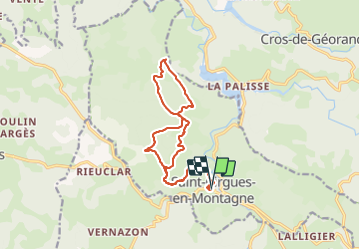

Length
15.2 km

Max alt
1266 m

Uphill gradient
392 m
Km-Effort
20 km

Min alt
1052 m

Downhill gradient
393 m
Boucle
Yes
Creation date :
2018-08-06 06:45:34.333
Updated on :
2021-06-11 12:17:01.757
4h35
Difficulty : Very easy

FREE GPS app for hiking
 SityTrail
IGN / Geographical institutes
SityTrail Plus
The world is yours!
About
Trail Walking of 15.2 km to be discovered at Auvergne-Rhône-Alpes, Ardèche, Saint-Cirgues-en-Montagne. This trail is proposed by raab.
Positioning
Country:
France
Region :
Auvergne-Rhône-Alpes
Department/Province :
Ardèche
Municipality :
Saint-Cirgues-en-Montagne
Location:
Unknown
Start:(Dec)
Start:(UTM)
586440 ; 4956388 (31T) N.
Comments